The Kalavasos and Maroni Built Environments Project, a collaborative research venture between Cornell University and Ithaca College, takes an interdisciplinary approach to investigating the relationships between architecture, social interaction and social change in Late Bronze Age Cyprus. It uses geophysical survey combined with digital recording and 3D modeling in an effort to shed light on the cityscapes of this transformative period.
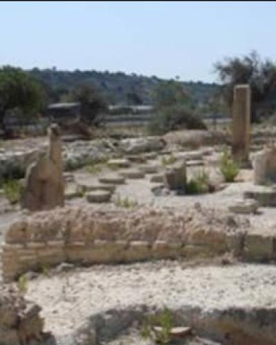
The Late Bronze Age (LBA; c. 1650-1100 BC) saw the island of Cyprus shift from a relatively insular and egalitarian, village-based society to an urbanized, cosmopolitan civilization with hierarchical sociopolitical organization. Previous research indicates that the new urban environments played a vital role in this profound social transformation by promoting social interactions that favored the interests of elites and underpinned their political power. Unfortunately, the dynamics of this process are not well understood and have not been systematically investigated. The major problem is that, while a number of Late Bronze Age sites on Cyprus have been partially excavated, we still have no clear picture of the anatomy of a Late Bronze Age city, i.e. how individual buildings were integrated into an overall urban landscape that structured social interaction.
Beginning in the spring of 2010, our project will conduct three, four-week seasons of geophysical prospection at the LBA urban centers of Kalavasos-Ayios Dhimitrios and Maroni, located in neighboring river valleys in south-central Cyprus, c. 7 km apart. Previous excavations at both sites revealed administrative complexes with monumental ashlar architecture and evidence for olive oil production and storage. At Kalavasos, the excavations unearthed small, isolated glimpses of what appears to be some form of orthogonal plan, while at Maroni, the physical relationship of the monumental buildings in the Vournes locality to the buildings excavated by Manning on the coast at nearby Tsaroukkas, is unclear. Using ground-penetrating radar, resistivity and magnetic survey, combined with digital mapping and modeling of the extent architecture, we hope to generate relatively complete urban plans of both sites. This will provide unprecedented insights into the role of the new urban environments as contexts for social interactions that supported and transformed broader social structures. It will also serve as a basis for future excavation work aimed at recovering high resolution data on the use of specific contexts of social interaction. In addition, we will produce a GIS-based database of architectural and archaeological data from the two sites that will serve as a powerful research and cultural resource management tool. These data will be made available to interested parties on the project website, which is currently under development.
Associated Faculty
Distinguished Professor of Arts and Sciences in Classical Archaeology